Monday, November 18, 2013


Mission Beta

By Jake Messner and Javire Chia-Hsing You

On November 9, 2013 we woke up at 4:45 A.M. to drive south and launch our second weather ballooning project, Mission Beta. The new payload contained sensors with significantly improved accuracy and decreased mass.


We inflated and launched our 6’ diameter balloon in Knox Town Park in central New York.


We watched our huge balloon and red parachute sail out of view before beginning our drive west. This time, our tracking operated via GPS, which meant that FCC regulations allowed us to track the balloon while in the air. As we drove east on the Mass Pike, we watched the balloon's blip on our map hurtle across central Massachusetts. The signal stopped moving near Hubbardston, MA and we turned north to recover the payload.

As we approached the balloon, the screaming 120 dB buzzer affixed to the payload’s side alerted us to the balloon’s position. Unfortunately, the buzzing was far above our heads, where the nylon tether had become tangled 60 feet high in a pine tree.


We found ourselves in another race against the clock to get the balloon out of the tree before darkness. After a quick trip to Wal-mart, we returned to the landing site with helium, party balloons, fishing line, and a bow and arrows. A nearby resident graciously allowed up to borrow his 24-foot extension ladder and a 30-foot pole. For two hours, we worked to recover our tantalizingly close payload. We designed a pulley system that was raised by helium balloons, attempting to loop 500 lb. fishing line around the payload capsule, but the wind gusts prevented us from finding our 60-foot high target.

We strung fishing line to the arrows and shot at the parachute, but both of were poor shots and we eventually tangled all our fishing line in the various surrounding trees. In a final effort as the sun slipped below the horizon, we climbed the 24-foot ladder and raised the 30-foot pole from the top. As expected, the pole swung dishearteningly far below the dangling white box.


Disappointed, we drove east to a friend’s house (Thanks Burns family!) to spend the night, not forgetting the image of a bright red parachute swinging in the wind. That night, we drew various recovery mechanisms and discussed their possibilities. We were thrilled about our ideas…and yet it was a difficult feat to access a violently swinging prismatic container, suspended high in a tree in woods owned by the state of Massachusetts. We couldn’t harm any trees and access was difficult due to surrounding small trees and tall shrubbery in the area. When morning came, we 
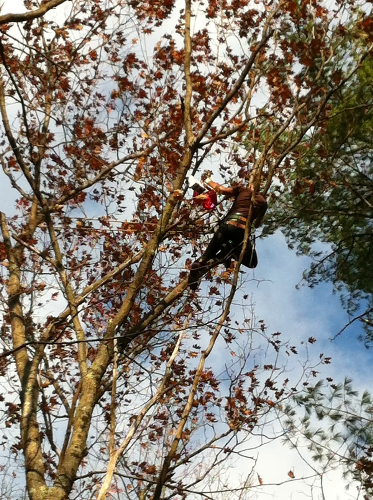
looked for help. Eugene Sokolovsky, a professional tree climber in Worcester, agreed to hike into the woods with us and climb the tree that had ensnared our payload. For less than the cost of constructing a new recovery device, Eugene was able to quickly scale a hardwood tree nearby and pull our parachute and capsule from the pine tree.


Excited to have finally recovered our payload, we opened it on the drive home and found the following data:

We obtained timed temperature and altitude readings during the ascent. During the descent, the temperature readings were highly inaccurate due to the rapid descent rate and the g-force affecting the thermometer chip. We also suspect that the thermometer stopped taking readings at approximately 29,000 meters because it froze.


The GoPro HERO2 HD took incredible footage for the duration of the flight. We will be posting the launch and flight videos to YouTube once they have been edited (right now, we have over six hours of video). As the balloon ascended, the camera captured arial shots of the central New York area.


At 100,000 feet, the majority of Earth's atmosphere appears as a blue sliver above the horizon and the sun shines from the blackness of space.


Our balloon popped spectacularly at approximately 103,000 feet, exploding in confetti-like strands of latex.


As the balloon descended, the GoPro captured shots of Massachusetts' Quabbin Reservoir and Asnacomet Pond before falling into the woods near Hubbardston.


Along with our camera and Arduino sensors, we also recovered our geiger counter and four canisters of film from the payload capsule. We plan to analyze and graph the data from these resources in the upcoming months to determine the effectiveness and continuity of the Ozone Layer in New York and Massachusetts. In Spring of 2014, we plan to launch a third balloon mission to measure the direct correlation between levels of radiation and specific atmospheric gases. Over the winter, we'll be planning for our third launch (Mission Gamma) and compiling our research for presentation in the Spring. 

Tuesday, November 12, 2013

Mission Beta Plan


Mission Beta

On October 6, we returned to Plattsburgh without the weather balloon we had taken on our trip south.

After three weeks on the verge of giving up, we received a call from southern New Hampshire. Our balloon, “Operation Defeat Icarus”, had landed on the 7-acre property of an astrophysicist.

Five days after receiving the call, a large Styrofoam package wrapped in aluminum foil was in my mailbox. The box’s contents told the story of a 120 mile, 95,000 foot high journey to the top of the ozone layer in temperatures ranging from -60 to 120 degrees Fahrenheit.

Our Arduino microcontroller provided data including temperature, altitude, and pressure. Radiation measurements were lost due to our long recovery time and our camera had malfunctioned. 

Only mildly deterred, we set out to improve on our project with a second balloon launch. This time, we chose the code name Mission Beta.

Materials:
800g Kaymont Balloon: ($85)
This balloon is considerably larger than the 600g balloon used in Operation Defeat Icarus. It will reach a burst altitude of 100,000 feet with a payload of three pounds.
Pocket Geiger 3: ($53)
This Geiger counter pairs with an Apple device and will provide significantly more accurate readings than were recorded in Operation Defeat Icarus.
600 Film: ($6)
Film will provide a measure of relative radiation by analyzing the damage done to the film in the ozone layer. In the event that the Pocket Geiger fails, the film will provide a secondary radiation meter.
Styrofoam Capsule: ($3)
Styrofoam will provide insulation and a confined payload package for all materials.
Chemical Hand Warmers: ($2)
Handwarmers will prevent the electronics from freezing at the -60 degree Fahrenheit temperatures at 30,000 feet. We will used fewer handwarmers than in Operation Defeat Icarus to conserve mass and because our new electronics are more weather-resistant.
GoPro HERO2 HD and 32GB Memory Card: ($205)
A GoPro will take high quality HD video recording of the capsule’s journey into near-space. Separating our camera from our tracking device will help conserve the battery life of both devices as well as providing higher quality data. The GoPro contains a 32 GB memory card that can hold approximately 16 high definition recording, significantly more than will be necessary for the flight.
~40 lb. Nylon Cord: ($6)
During Mission Beta, we will use a cord with an approximately 40 lb. break strength as opposed to the 25 lb. break strength cord used in Operation Defeat Icarus. This will ensure that the payload will not detach from the balloon during the descent or in strong thermal winds.
iPhone 4/iPod Touch: (already owned)
The Apple device will work as an interface for the Pocket Geiger, allowing it to record and log data for the entire flight time. If we use an iPhone 4 as the interface, we will also use it to run the application Find My iPhone in order to locate the phone should it fall in an area of AT&T cellular coverage.
SPOT 2 PLB: ($57 and $99 plan)
The SPOT 2 will be our primary tracking device. It used GPS signals to allow for online tracking. This device will be necessary should the payload fall in an area without any cellular coverage.
Helium: (~$175)
We will obtain our helium supply from Huan Welding or from Airgas in Plattsburgh. During Operation Defeat Icarus, we used an entire 60 ft3 tank, an entire 8.9 ft3 tank, and half of a second 8.9 ft3 tank for an approximate total of 74 ft3 of helium. This volume of helium filled the 500g balloon to an approximate diameter of 5 feet. For Mission Beta, we will inflate the balloon to an approximate diameter of 6 feet, an increase in volume by a factor of 1.728. It will require 127.88 ft3 of helium to inflate the balloon.  

Tracking:
The device will be tracked using two methods: Find My iPhone and the SPOT 2 GPS signal. These tracking methods overlap in coverage area, but each has unique qualities that make it useful. Find My iPhone relies on cellular service. The SPOT 2 operates anywhere in the continental United States, although the signal does not have a strong enough frequency to penetrate dense foliage or buildings. This will make the cell phone tracking devices more useful if the payload lands in an area in which a direct view of the sky is obscured. The SPOT 2 will be most useful if the payload lands in an area covered by neither Boost Mobile nor AT&T cellular service. Given our two tracking devices and their independent functionality, we estimate our chances of picking up a reliable signal upon landing at 90%.

Radiation:
The primary function of our payload will be to measure radiation in the Ozone Layer. The Ozone Layer extends from 13 to 17 miles high in the atmosphere, altitudes that our balloon will fly through the entirety of. Our Pocket Geiger will take radiation readings from launch; we hypothesize that these readings will begin increasing at an altitude of approximately 68,700 feet and will come to a stable level at an altitude of approximately 90,000 feet. This hypothesis can be explained by solar radiation filtering occurring in the ozone layer. We will additionally analyze radiation levels below the ozone layer to compare our findings to findings of others who theorize the presence of radiation bands throughout Earth’s atmosphere.

Photography:
The entire flight will be recorded using the GoPro HERO2 HD. The GoPro runs from a lithium battery that will easily sustain the cold with heat provided from chemical handwarmers. The photography taken during the flight will help us estimate the popping altitude of the balloon using timestamps and will deliver stunning views of Earth from over 18 miles high. Additionally, we are hoping to use the photography to observe the curvature of Earth.

Weather:
The launch will take place on November 9, 10, or 11. We have proven the weather balloon tracking website predict.habbub.org to be accurate in the past, so we will use this site to estimate the trajectory of our balloon’s flight. We will choose the day with the shortest expected weather balloon trajectory to minimize our recovery distance.

Flight Path:
After an analysis of cellular service in the northeastern United States, we have determined eastern Massachusetts to have the strongest AT&T cellular coverage. The cellular coverage map is shown below:


For this reason, we will estimate the recovery site of the payload to be near Worcester, MA. By using prediction information from habbub.com, we will choose a launch site that corresponds to a recovery site near this area. If the Jet Stream remains normal during this weekend, the launch site is expected to be near Albany, NY.

Recovery:
Western Massachusetts has very few bodies of water to cause concern, aside from the Atlantic Ocean in the east. The only major body of water near the estimated landing site is the Quabbin Reservoir in central Massachusetts. We expect our balloon to fly over the width of the reservoir such that it lands near Worcester, MA. The areas surrounding Worcester are composed of fairly thinly wooded property and farmland. We will bring a 30’ pole to the landing site to prepare for potential recovery from a tall tree. 

If we are able to successfully measure and analyze radiation in the upper atmosphere, we plan to present at the New York State Science and Engineering Fair in March and the Champlain Valley Regional Science Fair in April.